Community Mapping: Good for You, Good for Sustainable, Equitable Urban Growth
As the holiday season comes upon us again, are you thinking about any New Year’s resolutions? One popular New Year’s resolution is volunteering. Good news—Johns Hopkins Bloomberg School of Public Health researchers have found that the act of volunteering benefits older people through improved brain function. Their Baltimore Experience Corps study highlighted that participants particularly benefit from volunteerism that involves working in teams, problem-solving, walking throughout the day, and sharing knowledge.
The Taskar Center for Accessible Technology (TCAT) firmly believes in the benefit of volunteering. Besides brain health, volunteerism forges a sense of community, which is important for everyday living. As we transition into the “cities of the future” and develop community-based mapping tools for sustainable, equitable urban growth, TCAT has the explicit intent of engaging residents and not leaving any city dwellers behind.
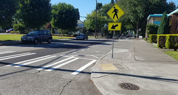
At face value, our community-based mapping programs document the built environment—primarily infrastructure and streets. In practice, groups of residents contribute to community resilience by discussing those portions of infrastructure that impact their health and well-being and documenting patterns of human behavior in that environment that enable (or are barriers). This work outsizes automated mapping that street-side cars produce on Google, Apple, Bing, and the like. More than a walking audit, the kind of detailed crowdsourcing and conversation our volunteer groups engage in can contribute to a greater understanding of where accessibility bottlenecks are, how much energy is required of people to negotiate certain places, and what kinds of opportunities the environment supports or discourages.
Mapping community travel options
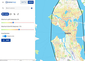
Click on the image above to go to AccessMap.io and search any Seattle address.
Our work creates data-driven tools that can help people make decisions about community travel that are right for them. To see an example of our end-user tools, check out the pedestrian-centered maps of Seattle, Bellingham, and Mt. Vernon on AccessMap.io. Looking at these maps, it is initially difficult to say how this might be different from the typical digital maps. A deeper look reveals that sidewalks and pedestrians are the focus.
Each sidewalk is colored based on the level of difficulty it presents to the user. As you change your profile to match your personal ability, the difficulty coloring each sidewalk will change dynamically with you. Don’t like hills? Tune down the maximum uphill incline until it’s at a comfortable setting for you.
When using the automated routing, paths are calculated based on other personal preferences you indicate. Thanks to the work of local contributors, AccessMap.io has settings that enable users to indicate a preference for curb ramps (use a wheelchair? push a stroller? toting a cart?) and even a preference for using indoor elevators in big public buildings. With locals contributing more information about how they travel, and specifics about sidewalk infrastructure they enjoy or dislike, there will be even more preferences enabled with time—like wanting better lighting or sidewalk quality. It’s a lot like communicating local lore and the nuances of your community, but instead of telling just one person at a time, you are sharing with an entire community of users and get to enjoy others’ knowledge about places unfamiliar to you.
Why this work makes a difference
This work makes a difference because there are no current adequate alternatives. We have all used digital maps with automated routing for pedestrians and been sent through streets with no sidewalks, unreasonable inclines, or ditches that we would have preferred to avoid.
AccessMap.io users tell us that the tool automatically identified routes for them that they have found personally but only after years of experience in those areas. In addition, users indicate that the personalized routing is helpful for navigating with wheelchairs and strollers, for teaching kids how to ride bikes, for orientation and mobility, for making street-parking choices on snowy days, and more.
But does this work make a difference beyond personal uses? The Taskar Center believes it could, and this is the journey we’d like to take with you. We believe this work presents opportunities for purposeful change, where communities support data-driven ways to influence the direction of built environment decisions in their immediate communities.
Too often, we hear that people feel their communities are changing too fast and they feel inadvertently marginalized by these changes. While urban change is somewhat inevitable today with communities having to invest in transportation infrastructure that enables people to forgo owning a car, it is clear that transportation infrastructure can be an equalizer (e.g., in Seattle, riders of public transit come from all socio-economic backgrounds) but it can also be an excluder (e.g., articles recount families or individuals without cars unable to leave their communities in emergencies, fires, or natural disasters). The difficulty in planning cities to counterbalance inequality is that data-driven decisions today are hailed as the right decisions, and much of the data does not tell or capture the full lived experience of all the people living in the community.
In 2020, we hope you will consider volunteering with the Taskar Center, helping to broaden the range of community stakeholders who contribute their experience. Join our team, help solve problems, walk, share knowledge, and help forge a stronger sense of community. Together, we can push to remove bias from data about our sidewalks and infrastructure and allow data-driven strategies to align with community resilience goals.
If you’re interested in leading or joining a group in your community, e-mail uwtcat@uw.edu.
Contributor Anat Caspi directs the Taskar Center for Accessible Technology at the University of Washington.